|
It was named after Morrison, Colorado,
where the first fossils were discovered by Arthur Lakes in 1877.
That same year, it became the center of the
Bone Wars, a
fossil-collecting rivalry between early paleontologists
Othniel Charles Marsh
and
Edward Drinker Cope.
According to radiometric dating, the
Morrison Formation dates from 156.3 ± 2 million years old (Ma)
at its base,
to 146.8 ± 1 million years old at the top,
which places it in the latest
Oxfordian,
Kimmeridgian, and early
Tithonian
stages of the late
Jurassic. This is similar in age to the
Solnhofen Limestone
Formation in Germany and the
Tendaguru Formation in
Tanzania. Throughout
the western USA, it variously
overlies the Middle Jurassic Summerville, Sundance, Bell Ranch,
Wanakah, and Stump Formations.
Deposition
At the time, the supercontinent of
Laurasia had recently
split into the continents of North America and
Eurasia, although they
were still connected by land bridges. North America moved north and was
passing through the subtropical regions.
The Morrison Basin, which stretched
from New Mexico in the south to Saskatchewan in the north, was formed when
the precursors to the Front Range of the
Rocky Mountains started pushing up to the west. The deposits from their
east-facing drainage basins,
carried by streams and rivers from the Elko
Highlands (along the borders of present-day Nevada and Utah) and deposited
in swampy lowlands, lakes,
river channels and floodplains, became the
Morrison Formation.
In the north, the
Sundance Sea, an
extension of the Arctic Ocean, stretched
through Canada down to the
United States. Coal is found in the
Morrison Formation of Montana, which means that the northern part of the
formation, along the shores of the sea, was wet and swampy, with more
vegetation. Eolian, or
wind-deposited sandstones are found in the southwestern part, which
indicates it was much more arid — a desert, with sand
dunes.
In the
Colorado Plateau
region, the Morrison Formation is further broken into four sub-divisions, or
members. From the
oldest to the most recent, they are:
-
Windy Hill Member:
The oldest member. At the time, the Morrison basin was characterized by
shallow marine and tidal flat deposition along the southern shore of the
Sundance Sea.
-
Tidwell Member:
The
Sundance Sea
receded to Wyoming during this member and was replaced by lakes and
mudflats.
-
Salt Wash Member:
The first purely terrestrial member. The basin was a semi-arid
alluvial plain,
with seasonal mudflats.
-
Brushy Basin Member:
Much finer-grained than the Salt Wash Member, the Brushy Basin Member is
dominated by mudstone rich in volcanic ash. Rivers flowed from the west
into a basin that contained a giant, saline alkaline lake called
Lake T'oo'dichi'
and extensive wetlands that were located just west of the modern
Uncompahgre Plateau.
Deposition in the Morrison Formation
ended about 147 Ma. The latest Morrison strata
 |
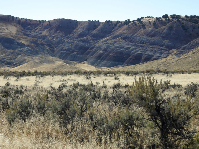
| Brushy Basin Member of the Morrison Formation, west of Green
River, Utah (Picture
Source) |
are followed by a
thirty-million year
gap in the geologic record.
The overlying units are the Lower Cretaceous Cedar
Mountain, Burro Canyon, Lytle, and Cloverly Formations.
Fossils
Though many of the Morrison Formation
fossils are fragmentary, they are sufficient to provide a good picture of
the flora and fauna in the Morrison Basin during the Kimmeridgian. Overall,
the climate was dry,
similar to a savanna but, since
there were no angiosperms (grasses,
flowers, and some
trees), the flora was
quite different. Conifers, the dominant
plants of the time, were to be found with
ginkgos,
cycads,
tree ferns, and
horsetail rushes. Much
of the fossilized vegetation was
riparian, living along
the river flood plains. Insects were very
similar to modern species, with termites building 30 m
(100 ft.) tall nests. Along the rivers, there were fish, frogs, salamanders, lizards, crocodiles, turtles, pterosaurs, crayfish, clams, and
monotremes (prototherian
mammals, the largest of
which was about the size of a
rat).
The dinosaurs were most
likely riparian as well (dwelled by rivers). Hundreds of dinosaur fossils have been discovered,
such as
Allosaurus,
Camptosaurus,
Ornitholestes, several
stegosaurs comprising
at least two species of
Stegosaurus and the
slightly older
Hesperosaurus, and the
early
ankylosaurs,
Mymoorapelta and
Gargoyleosaurus, most
notably a very broad range of
sauropods (the giants
of the Mesozoic era). Since at
least some of species are known to have nested in the area (Camptosaurus
embryoes have been
discovered), there are indications that it was a good environment for
dinosaurs and not just home to migratory, seasonal populations.
Sauropods that have been discovered
include the
Diplodocus (most
famously, the first nearly-complete specimen of
D. carnegiei, which is now
exhibited at the Carnegie Museum of Natural History,
in Pittsburgh, Pennsylvania),
Camarasaurus (the most
commonly found sauropod),
Brachiosaurus,
Apatosaurus (also
wrongly known as
Brontosaurus),
Barosaurus, the
uncommon
Haplocanthosaurus and
the
Seismosaurus. The very
diversity of the sauropods has raised some questions about how they could
all co-exist. While their body shapes are very similar (long neck, long
tail, huge elephant-like body), they are assumed to have had very different
feeding strategies, in order for all to have existed in the same time frame
and similar environment.
There are numerous excavation sites
within the Morrison, but the most famous is Como
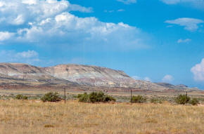 |
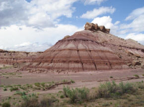
| Multicolored (variegated) beds of the Morrison Formation at Como
Bluff, Wyoming. Many historical dinosaur sites are located along the
flanks of the bluff. The Sundance Formation is visible as the
reddish beds at the base of the bluff. (Picture
Source) |
Bluff.
Como Bluff is a long ridge
extending east-west, located between the towns of
Rock River and
Medicine Bow,
Wyoming. The ridge is
an
anticline, formed as a
result of compressional geological folding. Three geological formations, the
Sundance, the
Morrison, and the
Cloverly Formations,
containing fossil remains from the
Late Jurassic of the Mesozoic Era, are
exposed at the bluff. Nineteenth century paleontologists
discovered many well-preserved specimens of dinosaurs, as well as mammals,
turtles, crocodilians, and fish from the Morrison Formation. Because of
this, Como Bluff is considered to be one of the major sites for the early
discovery of dinosaur remains. Among
the species discovered is the only known specimen of
Coelurus. Significant
discoveries were made in 22 different areas scattered along the entire
length of the ridge. It is included on the National Register of Historic Places
as well as the National Natural Landmark
list.
Dinosaur National Monument in Utah is
also a quarry site of the Morrison. For a list of quarry sites, see
Morrison Formation on Wikipedia.
Dinosaur National Monument
Dinosaur National
Monument is a National Monument located on the southeast flank of
 |
|
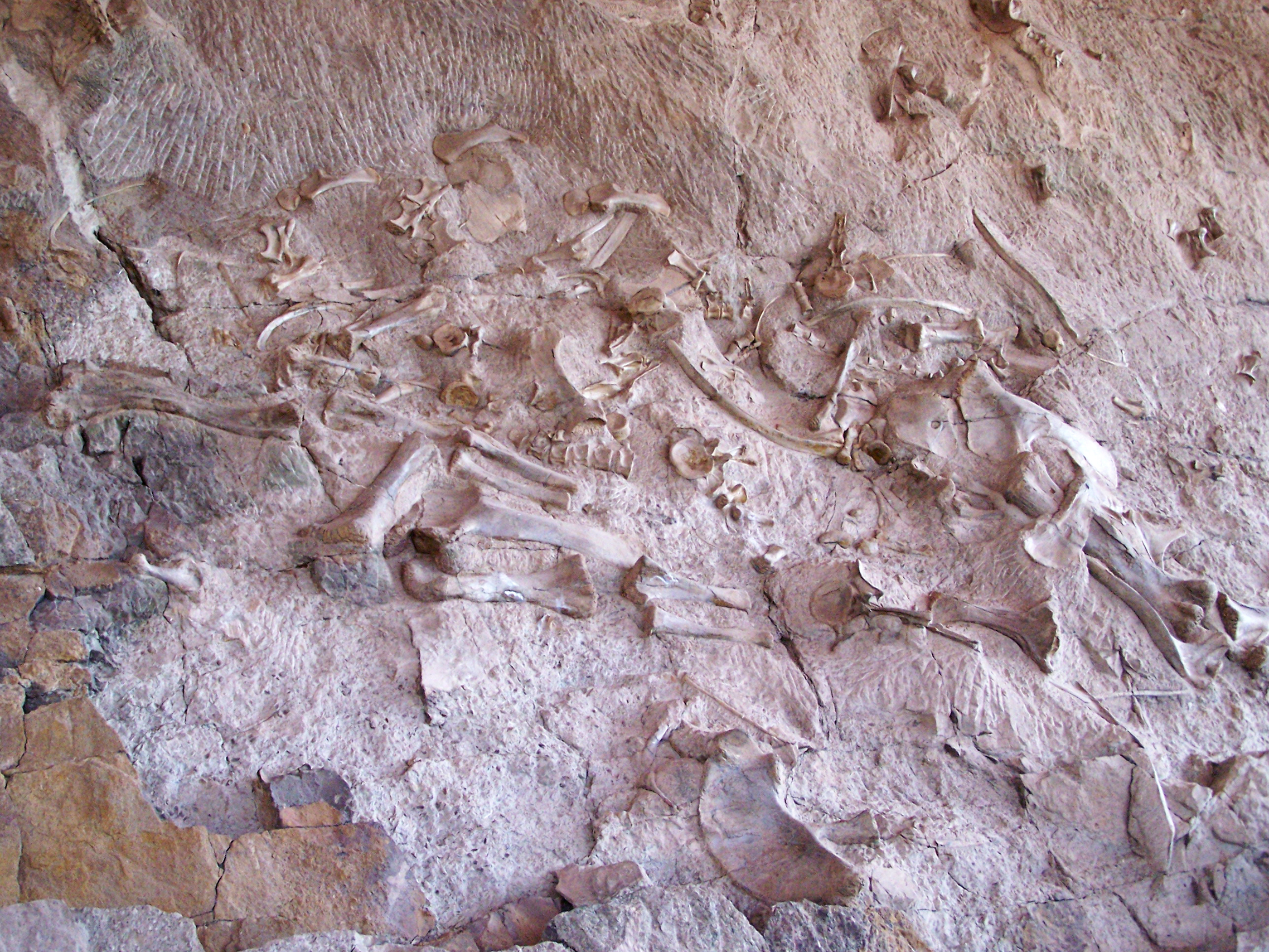
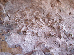
Above: Douglas Quarry. The dinosaur bones
now exposed on the Quarry cliff were buried in an ancient river
about 150 million years ago. Over time the sediments turned to rock,
protecting the bones in a stone time capsule. This photo shows a
"bone jam," made up of the fossilized bones of large sauropods. Huge
leg and shoulder bones of sauropods such as Apatosaurus and
Diplodocus dominate this section of the quarry face.
|
 |
|
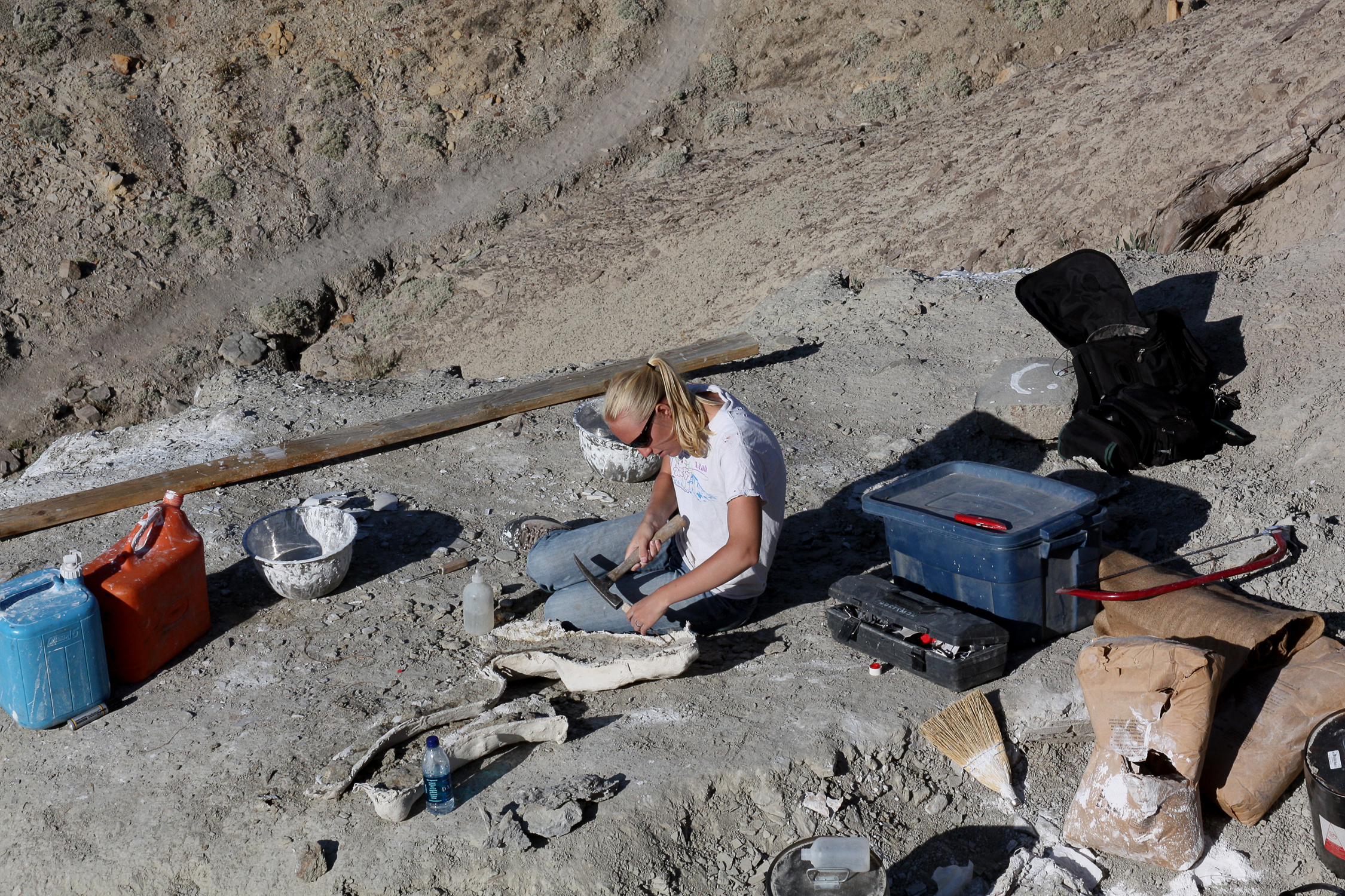
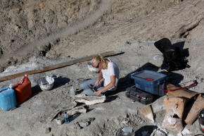
Paleontological field work at Dinosaur NM. Fossil
excavation often uses small tools, either pneumatic or manual, to
carefully remove rock from delicate fossils.
|
the
Uinta Mountains on the border between
Colorado
and Utah at the
confluence of the
Green and
Yampa
Rivers. Although most of the monument area is in
Moffat County, Colorado, the Dinosaur Quarry is located in Utah
just to the north of the town of
Jensen, Utah. This park has fossils of
dinosaurs
including
Allosaurus,
Abydosaurus, and various long-neck, long-tail sauropods.
The rock layer enclosing the
fossils is a
sandstone
and
conglomerate bed of
alluvial or river bed origin. The dinosaurs and other ancient animals
were washed into the area and buried presumably during flooding events. The
pile of sediments were later buried and lithified into solid rock. The
layers of rock were later uplifted and tilted to their present angle by the
mountain building forces that formed the Uintas. The relentless forces of
erosion
exposed the layers at the surface to be found by paleontologists.
When dinosaurs are found in a
mass graveyard, with many fossil specimens in one location such as Dinosaur
National Monument, the remains are deposited in that location due to water,
typically from a flood event, or several flood events. Young earth
creationists often point to these mass graveyards as proof of the worldwide
flood of Noah, and they claim it is proof that the earth is young.
However, there are many reasons why this is not the case.
-
The geologic record is full of examples of many
individual flood events, separated by rock layers that are non-flood
rocks, such as desert sandstones.
-
Dinosaurs in mass graveyards typically display
evidence that they were scavanged by other dinosaurs, such as bite marks
and teeth left behind by feeding dinosaurs. Dinosaurs rapidly
buried by a great single flood would not be scavanging other carcasses,
as they themselves would have been buried.
-
The rock layers containing dinosaurs, such as the
Morrison, are located on top of thousands of feet of rock layers that
are also considered Flood deposits. They could not have survived
during the deposition of these rock layers.
-
If all the dinosaurs we see in the rock record
existed at the same time as Noah's Flood, then we would expect to see
mass graveyards containing hundreds of species of dinosaurs. Most
mass graveyards contain only a handful of species.
On the other hand, old earth
creationism has no problems with accepting the theories of scientists, who
view these graveyards as created by individual floods, or by a group of
floods. (For additional reading - As an example of a young earth claim
about a dinosaur graveyard, consider this
young earth claim.)
End
of Reading

Return to the
Old Earth Ministries Online Earth
History Curriculum homepage.
|