Origin and Geology
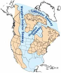
The Seaway was created as the now inexistent Farallon and North American tectonic plates collided, causing the Rocky Mountains to form in western North America and the creation of a depression or Foreland basin in the middle North America. This depression and the high eustatic sea levels existing during the Cretaceous allowed waters from the Arctic Ocean in the north and the Gulf of Mexico in the south to meet and flood the central lowlands, forming a sea that transgressed (grew) and regressed (receded) over the course of the Cretaceous.
The earliest phase of the Seaway began in the mid-Cretaceous, when an arm of the Arctic Ocean transgressed south over western North America; this formed the Mowry Sea, so named for the Mowry Shale, a characteristic rock formation that is rich in oil shale. In the south, the Gulf of Mexico was an extension of the Tethys Sea, which met with the Mowry Sea in the late Cretaceous, forming the "complete" Seaway.
At its largest, the Western Interior Seaway stretched from the Rockies to the Appalachians in the east, some 1000 km wide. At its deepest, it may have been only 800 or 900 meters deep, shallow in terms of seas. Two great continental watersheds drained into it from east and west, diluting its waters and bringing resources in eroded silt that formed shifting delta systems along its low-lying coasts. There was little sedimentation on the eastern shores of the Seaway; the western boundary however, consists of a thick clastic wedge eroded eastward from the Sevier orogenic belt. The western shore was thus highly variable, depending on variations in sea level and sediment supply.
Widespread carbonate deposition suggests that the Seaway was warm and tropical, with abundant calcareous algae. Rudy Slingerland of Penn State University has computer-modelled a counter-clockwise gyre for the Cretaceous Seaway, with cooler waters flowing south along the eastern seacoasts of Wyoming and Colorado.
At the end of the Cretaceous continuing uplift in a mountain-building episode called the Laramide orogeny hoisted the sandbanks (sandstone) and muddy brackish lagoons (shale), the thick sequences of silt and sandstone still seen today as the Laramie Formation, while low-lying basins between them gradually subsided. The Western Interior Seaway divided across the Dakotas and retreated south towards the Gulf of Mexico. This shrunken, regressive phase of the Western Interior Seaway is sometimes called the Pierre Seaway.
During the early Paleocene, parts of the Western Interior Seaway (marine waters) still occupied areas of the Mississippi Embayment, submerging the site of present-day Memphis. Later transgression however, was associated with the Cenozoic Tejas sequence, rather than with the previous event responsible for the Seaway.
Fauna
The Western Interior Seaway was a shallow sea, filled with abundant marine life. Interior Seaway denizens included predatory marine reptiles, the largest animals in the Cretaceous seas: mosasaurs growing up to 18 meters long, ichthyosaurs (one specimen from Pink Mountain in British Columbia is currently the largest ichthyosaur specimen found to date). Other marine life included sharks, such as Squalicorax, and advanced bony fish including Pachyrhizodus, Enchodus, and the massive 5-meter long Xiphactinus, a fish larger than any modern bony fish. Other sea life included invertebrates such as mollusks, ammonites, squid-like belemnites, and plankton including coccolithophores that secreted the chalky platelets that give the Cretaceous its name, foraminiferans and radiolarians.
The Western Interior Seaway was also home to early birds, including the flightless Hesperornis, which had stout legs for swimming through the water and small wing-like appendages used for marine steering rather than flight; and the tern-like Ichthyornis, an early avian with a toothy beak.
On the bottom the giant clam Inoceramus has left common fossilized shells in the Pierre Shale. The clam had a thick shell paved with "prisms" of calcite deposited perpendicular to the surface, which gave it a pearly luster in life. Paleontologists suggest that the giant size was an adaptation for life in the murky bottom waters, where a correspondingly large gill area would have allowed the animal to cope with oxygen-depleted waters.
B. Niobrara Formation
The Niobrara Formation, also called the Niobrara Chalk,
is a
geologic formation in North America that was laid down between 87 and 82
million years ago during the
Coniacian,
Santonian, and
Campanian ages of the
Late Cretaceous.
It is composed of two structural units, the
Smoky Hill Chalk
Member overlying the
Fort Hays Limestone Member. The chalk formed from the accumulation of
coccoliths from
microorganisms living in what was once the
Western
Interior Seaway, an inland sea that divided the continent of North
America during much of the Cretaceous. It underlies much of the Great Plains of the US and Canada.
Evidence of vertebrate life is common throughout the formation and includes
specimens of plesiosaurs,
mosasaurs, and
pterosaurs as well as
several primitive aquatic birds.
The
type
locality for the Niobrara Chalk is
Knox County
in northeastern
Nebraska.
C. Hell Creek Formation
|
|
|
The Hell Creek Formation is well exposed in the badlands in the vicinity of Ft. Peck Reservoir in northeast Montana. |
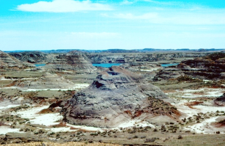
The Hell Creek Formation is an intensely-studied division of Upper Cretaceous to lower Paleocene rocks in North America, named for exposures studied along Hell Creek, near Jordan, Montana.
The Hell Creek Formation occurs in Montana and portions of North Dakota, South Dakota, and Wyoming. In Montana, the Hell Creek Formation overlies the Fox Hills Formation and is the uppermost formation of the Cretaceous period. "Pompey's Pillar" at the Pompeys Pillar National Monument is a small isolated section of the Hell Creek Formation.
It is a series of fresh and brackish-water clays, mudstones, and sandstones deposited during the Maastrichtian, the last part of the Cretaceous period, by fluvial activity in fluctuating river channels and deltas and very occasional peaty swamp deposits along the low-lying eastern continental margin fronting the late Cretaceous Western Interior Seaway. The climate was mild, and the presence of crocodilians suggests a sub-tropical climate, with no prolonged annual cold. The famous iridium-enriched K-T boundary, which separates the Cretaceous from the Cenozoic, occurs as a discontinuous but distinct thin marker bedding within the Formation, near its uppermost strata.
Commercial excavations bring Hell Creek fossils onto the market, usually dinosaur teeth, crocodylian osteoderm fragments, and dermal plates of fossil gars. A representative selection of Hell creek fossils can be seen at the Museum of the Rockies, in Bozeman, Montana.
The formation has produced impressive assemblages of invertebrates, plants, mammals, fish, reptiles, and amphibians. Notable dinosaur finds include Tyrannosaurus and Triceratops. The most complete Hadrosaurid dinosaur ever found was retrieved in 2000 from the Hell Creek Formation and widely publicised in a National Geographic documentary aired in December 2007. A few bird, mammal, and pterosaur fossils have also been found. Teeth of sharks and rays are sometimes found in the riverine Hell Creek Formation, suggesting that some of these taxa were tolerant of fresh water then as now.
End of Reading
Return to the Old Earth Ministries Online Earth History Curriculum homepage.
Source Pages: Western Interior Seaway, Niobrara Formation, Hell Creek Formation