Begin today's lesson by watching this short video, National Geographic - Amazing Flight Over the Grand Canyon.
Uplift and Nearby Extension
The Laramide orogeny affected all of western North America by helping to build the
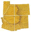 |
| Uplift of the Colorado Plateaus |
Around 18 million years ago, tensional forces started to thin and drop the region to the west, creating the Basin and Range province. Basins (grabens) dropped down and mountain ranges (horsts) rose up between old and new north–south–trending faults. However, for reasons poorly understood, the beds of the Colorado Plateaus remained mostly horizontal through both events even as they were uplifted about 2 miles (3.2 km) in two pulses. The extreme western part of the canyon ends at one of the Basin and Range faults, the Grand Wash, which also marks the boundary between the two provinces.
Uplift from the Laramide orogeny and the creation of the Basin and Range province worked together to steepen the gradient of streams flowing west on the Colorado Plateau. These streams cut deep, eastward-growing, channels into the western edge of the Colorado Plateau and deposited their sediment in the widening Basin and Range region.
Colorado River's Birth and its Cutting Down
Rifting started to create the Gulf of California far to the south 6 to 10 million years ago. Around the same time, the western edge of the Colorado Plateau may have sagged
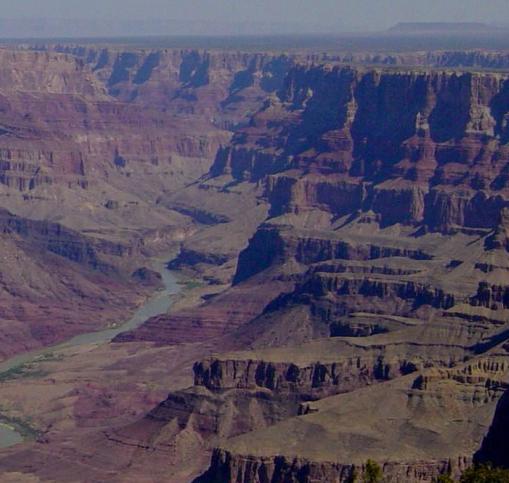 |
| The Colorado River had cut down to nearly the current depth of the Grand Canyon by 1.2 million years ago. (Picture Source) |
At the same time, streams flowed from highlands in central Arizona north and across what is today the western Grand Canyon, possibly feeding a larger river. The mechanism by which the ancestral Lower Colorado River captured this drainage and the drainage from much of the rest of the Colorado Plateau is not known. Possible explanations include headward erosion or a broken natural dam of a lake or river. Whatever the cause, the Lower Colorado likely captured the landlocked Upper Colorado somewhere west of the Kaibab Uplift. The much larger drainage area and yet steeper stream gradient helped to further accelerate downcutting.
Ice ages during the Pleistocene brought a cooler and wetter pluvial climate to the region starting 2 to 3 million years ago. The added precipitation increased runoff and the erosive ability of streams (especially from spring melt water and flash floods in summer). With a greatly increased flow volume the Colorado cut faster than ever before and started to quickly excavate the Grand Canyon 2 million years before present, almost reaching the modern depth by 1.2 million years ago.
The resulting Grand Canyon of the Colorado River trends roughly east to west for 278 miles (447 km) between Lake Powell to Lake Mead. In that distance, the Colorado River drops 2,000 feet (610 m) and has excavated an estimated 1,000 cubic miles (4,200 km3) of sediment to form the canyon. This part of the river bisects the 9,000-foot (2,700 m)-high Kaibab Uplift and passes seven plateaus (the Kaibab, Kanab, and Shivwits plateaus bound the northern part of the canyon and the Coconino bounds the southern part). Each of these plateaus are bounded by north to south trending faults and monoclines created or reactivated during the Laramide orogeny. Streams flowing into the Colorado River have since exploited these faults to excavate their own tributary canyons, such as Bright Angel Canyon.
Volcanic Activity Dams the New Canyon
Volcanic activity started in Uinkaret volcanic field (in western Grand Canyon) about 3 million years ago. Over 150 flows of basaltic lava dammed the Colorado River at least
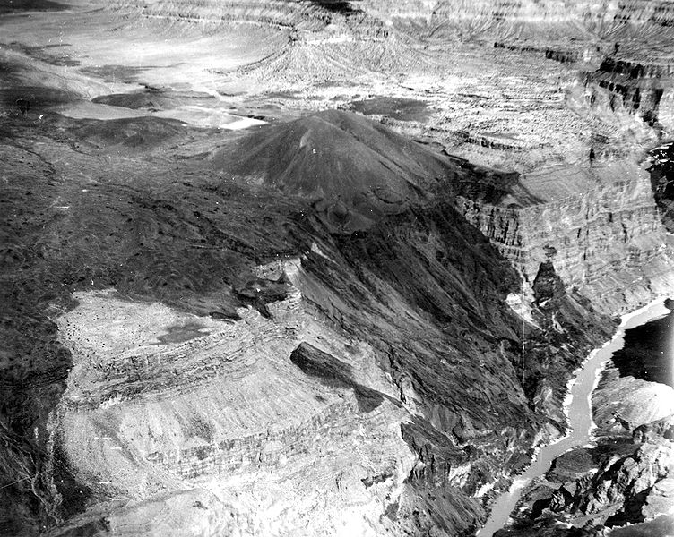 |
| Vulcan's Throne volcano above Lava Falls. Lava flows, such as this heavily eroded remnant, once dammed the Colorado River. |
The longevity of the dams and their ability to hold Colorado River water in large lakes has been debated. In one hypothesis water from the Colorado River backed up behind the dams in large lakes that extended as far as Moab, Utah. Dams that were 150 to 400 feet (46 to 120 m) high were overtopped by their lakes in 2 to 17 days while dams 200 to 1,000 feet (61 to 300 m) high were overtopped in 22 years. At the same time, sediment filled the lakes behind the dams. Sediment would fill a lake behind a 150-foot (46 m)-high dam in 10.33 months, filled a lake behind an 1,150-foot (350 m)-high dam in 345 years, and filled the lake behind the tallest dam in 3000 years. Cascades of water flowed over a dam while waterfalls migrated up-river along it. Most lava dams lasted for around 10,000 to 20,000 years. However others have proposed that the lava dams were much more ephemeral and failed catastrophically before overtopping. In this model dams would fail due to fluid flow through fractures in the dams and around dam abutments, through permeable river deposits and alluvium.
Since the demise of these dams the Colorado River has carved a maximum of about 160 feet (49 m) into the rocks of the Colorado Plateau.
Ongoing Geology and Human Impact
The end of the Pleistocene ice ages and the start of the Holocene began to change the area's climate from a cool, wet pluvial one to dryer semi-arid conditions similar to that of today. With less water to cut, the erosive ability of the Colorado was greatly reduced. Mass wasting processes thus began to become relatively more important than they were before. Steeper cliffs and further widening the Grand Canyon and its tributary canyon system occurred. An average of two debris flows per year reach the Colorado River from tributary canyons to form or expand rapids. This type of mass wasting is the main way the smaller and steeper side canyons transport sediment but it also plays a major role in excavating the larger canyons.
In 1963 Glen Canyon Dam and other dams farther upstream started to regulate the flow of the Colorado River through Grand Canyon. Controlling river flow by use of dams has diminished the river's ability to scour rocks by substantially reducing the amount of sediment it carries. Dams on the Colorado River have also changed the character of the river water. Once both muddy and warm, the river is now clear and averages a 46 °F (8 °C) temperature year-round.
Grand Canyon lies on the southern end of the Intermountain West seismic belt. At least 35 earthquakes larger than 3.0 on the Richter Scale occurred in the Grand Canyon region in the 20th century. Of these, five registered over 5.0 on the Richter Scale and the largest was a 6.2 quake that occurred in January 1906.
Grand Canyon and Creation Science
The Grand Canyon is of intense interest to young earth creationists. They view the formation of the canyon as testimony to the worldwide flood of Noah. As old earth creationists, we accept that the canyon was formed over millions of years, through the processes explained above, and that Noah's flood was a local flood event.
The standard young earth explanation is that the rock layers of the canyon are the result of deposition during the flood of Noah, and that the carving of the canyon occurred over a short period of time (weeks), as a great lake near the canyon flooded it and rapidly eroded the rock.
In believing this theory, YEC proponents typically ignore the fact that the fossils of the canyon tell a different story. As previously mentioned, there are no dinosaur fossils in the rocks in the canyon. All the evidence for living dinosaurs occurs in rock layers above the canyon. These rock layers are eroded away in Arizona, but they are present further north and east. If the Grand Canyon rock layers were formed from the flood, we would expect them to contain dinosaur fossils, along with fossils of mammals, including humans, that were killed in the flood. Instead, they show a steady progression of life forms as God created them more and more complex.
One of the key
targets of young earth creationists is the Coconino Sandstone. This is
a wind-blown, desert sandstone. They attack this rock layer because
you cannot have a desert rock layer deposited in the middle of Noah's flood.
Old Earth Ministries has an article that explains why the young earth
explanation is in error (Optional Reading:
Click here
for the article). Even more troubling for young earth creationism, there was
another wind-blown, desert sandstone, the Navajo Sandstone, that is
stratigraphically above the Grand Canyon. Young earth creationists
completely ignore this sandstone since it is not in the Grand Canyon.
End of Reading
Return to the Old Earth Ministries Online Earth History Curriculum homepage.
Source: Grand Canyon, Geology of the Grand Canyon Area