
Creation Science Rebuttals -
Stratigraphy and the Young Earth Global Flood Model - Part 3
by Greg Neyman
© Old Earth Ministries
First Published 26 Jan 2003
Old Earth Ministries Website
Revised and Expanded February 2006
When we go further up the geologic column from the rock layers of the Grand Canyon, we have even stronger evidence against the young earth creation science flood model. First, I'll provide a listing of the next rock layers stratigraphically above the Grand Canyon. You may be saying, "But there are no rocks above the Grand Canyon." An explanation is in order first.
In the area of the Grand Canyon, there used to be two more rock layers, which are now eroded away from the Canyon area. However, these rock layers still exist away from the canyon. If you will recall, the topmost rock layer at the canyon is the Kaibab Limestone. As you travel away from the canyon, you will come across a layer of rock on top of the Kaibab. This rock layer is the Moenkopi. A little further, and you come across the Chinle. These layers are now eroded away from the Grand Canyon, but since they exist a short distance away, and on top of the Kaibab, we know they were deposited after the Kaibab. If you continue away from the Grand Canyon, you will come across layer after layer, several thousand more feet of sediment, all of which is younger in age than the Grand Canyon rocks. Therefore, these layers are said to be stratigraphically above the Grand Canyon rocks.
Sometimes rock layers hundreds of feet thick may be in one location, but not in others. To simplify our discussion, we will move from the Grand Canyon to the geology of Zion National Park. The rock layers at Zion are as indicated in the graphic, and comprise about 6,000 feet of deposition.
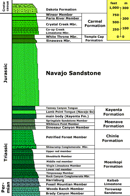
Graphic courtesy of the US. Geological Survey
Discussion
The lowermost formations, the Toroweap and Kaibab, are the two top-most layers at the Grand Canyon. Thier presence at Zion National Park provides a reference point for our continued progress up the stratigraphic column.
The Moenkopi Formation
This 230 million year old formation contains mudstones, limestones, sandstones, shales, and siltstones, and gypsum. This formation reaches thicknesses of 1,800 feet, and is comprised thousands of these alternating layers, clearly indicating a shallow, fluctuating shoreline. It is unclear how young earth creationists would fit it in their model, given the clear evidence in the middle of the flood of thousands of advances and retreats of the shoreline. It provides clear testimony against the young earth flood model.
Chinle Formation
This interesting rock layer contains shale, gypsum, limestone, sandstone, and many important minerals such as iron, magesium, and uranium ore. There are also layers of volcanic ash, and petrified wood and fossils are plentiful (this is the formation at the Petrified Forest National Park). It is about 550 feet thick. The gypsum formed from lagoon deposits. Given the worldwide flood model of young earth creation science, there should be no lagoons. Again, we have many alternating layers of sand, silt, and limestone, providing proof of an advancing and retreating shoreline, which again is inexplicable within the context of the young earth flood model. Some sources say this is the first layer with trace fossils for dinosaurs.
Moenave Formation
Early Jurassic uplift was accompanied by deposition of the Moenave Formation. The oldest beds of this formation belong to the reddish, slope-forming thin beds of siltstone interbedded with mudstone and fine sandstone of its Dinosaur Canyon Member, 140 to 375 feet thick (43 to 114 m), which was probably laid down in streams, ponds and large lakes (evidence for this is in cross-bedding of the sediments and large numbers of fish fossils).
Pale reddish-brown and 75 to 150 feet thick (23 to 46 m), the cliff-forming Springdale Sandstone is the upper member of the Moenave. It was deposited in swifter, larger, and more voluminous streams than the older Dinosaur Canyon Member. Fossils of large sturgeon-like freshwater fish have been found in the beds of the Springdale Sandstone. The next member in the Moenave Formation is the thin-bedded Whitmore Point, which is made of mudstone and shale. The lower red cliffs seen from the Zion Human History Museum (until 2000 the Zion Canyon Visitor Center) are good, easy to see examples of this formation.1
You may have noticed key words, such as streams, ponds, and large lakes, all features that should not be present on a globe full of water. Again we have interbedded siltstone, mudstone, and sandstone, indications of fluctuations in shoreline. It clearly does not fit the young earth model.
Kayenta Formation
At 200 to 600 feet thick (60 to 180 m), the Kayenta
Formation's sand and silt were laid down in early Jurassic time in
slower-moving, intermittent streambeds in a semiarid to tropical
environment. Fossilized dinosaur footprints from sauropods have been found
up the Left Fork of North Creek in this formation. Today the Kayenta is a
red and mauve rocky slope-former made of sandstone, shale, and siltstone
that can be seen throughout Zion Canyon.1
Here we have clear evidence of streambeds, which
contradicts the young earth model. Of the greatest interest here,
however, is the first trace of dinosaurs (tracks). We are now about
8,000 feet up the stratigraphic column from where the flood started (the
rocks at the bottom of the Grand Canyon, and we suddenly have sauropod
dinosaurs walking around...in the middle of Noah's Flood! More on this
later when we discuss the Morrison Formation.
Navajo Sandstone
Approximately 190 to 136 million years ago in the
Jurassic the Colorado Plateau area's climate increasingly became arid until
150,000 square miles (388,000 km²) of western North America became a huge
desert, not unlike the modern Sahara. For perhaps 10 million years sometime
around 175 million years ago sand dunes accumulated, reaching their greatest
thickness in the Zion Canyon area; about 2200 feet (670 meters) at the
Temple of Sinawava in Zion Canyon.
Most of the sand, made of 98% translucent,
rounded-grain quartz, was transported from coastal sand dunes to the west
(what is now central Nevada). Today the Navajo Sandstone is a geographically
widespread pale tan to red cliff and monolith former with very obvious sand
dune cross-bedding patterns. Typically the lower part of this remarkably
homogeneous formation is reddish from iron oxide that percolated from the
overlaying iron-rich Temple Cap formation while the upper part of the
formation is a pale tan to nearly white color. The other component of the
Navajo's weak cement matrix is calcium carbonate, but the resulting
sandstone is friable (crumbles easily) and very porous. Cross-bedding is
especially evident in the eastern part of the park where Jurassic wind
directions changed often. The crosshatched appearance of Checkerboard Mesa
is a good example.1
The Navajo is one of my favorite sandstones.
Since it is desert in origin, and their could not possibly be a wind-blown
desert in the middle of Noah's Flood, it provides solid evidence against the
young earth global flood model.
Temple Cap Formation (Middle Jurassic)
In early Mid Jurassic time streams loaded with iron-oxide-rich mud flooded and partially leveled the sand dunes, creating the Temple Cap Formation. Thin beds of clay and silt mark the end of this formation as desert conditions briefly returned to the area. The most prominent outcrops of this formation make up the capstones of East Temple and West Temple in Zion Canyon. Rain dissolves some of the iron oxide and thus streaks Zion's cliffs red (the red streak seen on the Alter of Sacrifice is a famous example). Temple Cap iron oxide is also the source of the red-orange color of much the lower half of the Navajo Formation.1
Once again, we have terrestrial streams and desert sand dunes, clear evidence against Noah's Flood.
In case you may be thinking that the flood should be over now, and these were deposited after the flood...all the mammal fossils, and almost all the dinosaur fossils are located above this rock layer, thus negating this as the endpoint of the flood.
Carmel Formation
Warm, shallow sea started to advance into the region (transgress) 150 million years ago, finishing the job of flattening the sand dunes. Sedimentation beds one to four feet thick (30 to 120 cm) of limy ooze with some sand and fossils occurred from Mid to Late Triassic time. Some calcareous silt peculated down into the buried sand dunes (carrying red oxides with it) and eventually cemented them into the sandstone of the Navajo Formation. The limy ooze above would later lithify into the hard and compact limestone of the Carmel Formation, 200 to 300 feet thick (60 to 90 m), which is notably exposed on Horse Ranch Mountain in the Kolob Canyons section of the park and near Mt. Carmel Junction east of the park.1
Unconformity
A gap in the geologic record, an unconformity, follows
the Carmel Limestone. Other formations totaling 2,800 feet (850 m) thick may
have been deposited in the region during Late Jurassic and Early Cretaceous
only to be uplifted and entirely removed by erosion.1
Dakota Formation
This formation consists of a basal conglomerate and fossil-rich sandstone and was laid down during the Cretaceous period. Although this is the top layer of rock at Zion National Park, the story does not end there. As you go north, other layers come into play, the most important one being the Morrison Formation, which is actually under (older) than the Dakota.
Conclusion
In this section, we have witnessed many rock layers with clear evidence of repeatedly advancing and retreating shorelines, terrestrial streams, and even a desert formed sandstone. According to the young earth creation science model for the flood, we should have one big ball of water, with no landforms exposed. Clearly the young earth model cannot answer these problems.
1 Geology of the Zion and Kolob Canyons Area, from Wikipedia, the free internet encyclopedia
http://en.wikipedia.org/wiki/Geology_of_the_Zion_and_Kolob_canyons_area
If you are not a Christian, and you have been holding out on making a decision for Christ because the Church always preached a message that was contrary to what you saw in the scientific world, then rest assured that the Bible is the inerrant Word of God, and you can believe in Christ and receive salvation, while still believing in an old earth. Click here for more.
Are you a Christian who believes in young earth creationism? Now that we have shown the many difficulties of the young earth creation science model in this and many other articles, how does this impact your Christian life? If you are a young-earth creationism believer, click here.
Print-Friendly PDF Version of this page
Part 3
Other Relevant Old Earth Ministries Articles
Noah’s Flood – Is the Young Earth Creation Science Model for Noah’s Flood right?
A Bridge Over Troubled Waters - A Scientific Look Into the Genesis Flood Account
Can You Be A
Christian and Believe in an Old Earth?
Feel free to check out more of this website. Our goal is to
provide rebuttals to the bad science behind young earth creationism,
and honor God by properly presenting His creation.