
Creation Science Rebuttals -
Stratigraphy and the Young Earth Global Flood Model - Part 5
by Greg Neyman
© Old Earth Ministries
First Published 26 Jan 2003
Old Earth Ministries Website
Revised and Expanded February 2006
In this final part, we will examine stratigraphy from 65 million years ago to the present. This time is known as the Cenozoic Era. For this part, we will continue to examine the rock layers at Flaming Gorge.
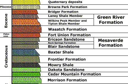
Graphic courtesy of the US. Geological Survey
Fort Union Formation
The Fort Union formation spans the Cretaceous-Paleocene boundary, 65 million years ago. The most important thing about this formation is that the great coal fields in the Powder River Basin in Wyoming are in this formation. Considering that almost 14,000 feet of sediment had already been deposited by the so-called global flood, how can it be that such a great amount of vegetation would still be on the surface, many months after the start of Noah's Flood? Once again, the young earth model cannot explain this.
Wasatch Formation
The description of this unit is from the Fossil Basin of Wyoming. Wasatch Formation is divided into several members.1
The lower member is an irregular sequence of flood-plain and stream-channel deposits. Mudstone is the prevalent rock type, and can be tan, brown, pink, red, or gray. There are also black carbonaceous siltstones, gray sandstones, cross-bedded conglomerate, and other sandstones. Limestone occurs in lenses.
The main body of the formation is responsible for the spectacular red badlands in Fossil Butte National Monument. Color can also be pink, purple, yellow, or gray. Individual color bands range from 1 to 10 feet thick, with the brighter colors towards the top. The prevalent rock types are the banded mudstone, with interlayered sandstone, conglomerate, marlestone, siltstone, and claystone. The conglomerates occur as channel fills (as in streambeds).
Next there is a sandstone tongue, with cross-bedding. It is brown with some black chert grains. It phases out towards the north. Most likely tectonic events caused an uplift and erosion of Mesozoic and Paleozoic rocks in the Uinta Mountains and debris was deposited in Fossil Lake as an encroaching delta of sand. When deposition of the sand halted, the lake expanded and covered the sand, encasing it within the shales of the Green River Formation.
Next is a mudstone tongue. It and the previous sandstone tongue are interlayered with the lower layers of the Green River Formation. This tongue is dark red mudstone, changing to light red, pink or greenish-gray claystone towards the basin. The unit is a mixture of silt and clay derived from the north and west, and was deposited as a large delta in Fossil Lake.
Next is the Bullpen Member. The rocks included within the Bullpen Member are layered sequences of red, pink, gray, and green claystone and mudstone. Bentonite is present in some claystone beds and causes sloughing because of its property of expanding when wet. Some sandstones are present in the northern areas of the member's distribution. Limestones are also present.
Geologically speaking, the Bullpen Member is conformable with the underlying Angelo Member of the Green River Formation. The contact is a transitional one reflecting a gradual change from the lake environment of the Green River Formation through a swamp environment to that of a flood plain. The light-colored, fine-grained shales, marlstones, and limestones of the Green River Formation grade upward into drabber, coarser grained clay and mudstones of the Bullpen Member as a reflection of this change of environments. As with other formations, a lake/swamp environment is contrary to the young earth creation science model.
The final member of the Wasatch is the Tunp Member. It intertongues with nearly all of the Wasatch and the overlying Green River formation. The member grades laterally basinward from coarse, angular conglomerates to fine mudstone. Two limestone tongues of the Green River Formation are interbedded with the Tunp, indicating that at least twice there was major expansion of the lake.
The Tunp is a red, conglomeratic, sandy mudstone with angular, poorly rounded to smooth, well-rounded clasts with a size range from pebble to boulder. It is thought to have originated from mudflows and gravity slides.
Overall, the Wasatch is thought to be deposited mainly by streams flowing into Fossil Basin from the surrounding highlands. Mudstones and siltstones were probably deposited along floodplains, with sands and conglomerates from the stream channels. The presence of palms in the lake sediments and of bones of primates and crocodiles in both the lacustrine and fluvial sediments indicate a heavily forested, tropical environment. Naturally, such an environment could not exist in the middle of Noah's Flood.
Green River Formation
The Green River Formation has been the subject of much talk within young earth creation science circles. This is a formation made up of millions of thin layers known as varves. Since we have discussed varves elsewhere, we will not discuss them here at length. If you are interested, you can check out the article Truth In Geology: Varves.
The formation is lacustrine in origin, and is actually made up of several deposits from several different lakes that were contemporary. Many excellent fish fossils are found within the Green River, as well as plants, insects, reptiles, birds, and mammals. To learn more on the Green River Formation, visit Localities of the Eocene: The Green River Formation.
The young earth explanation for the formation is non-existent. They have hinted at the millions of varves being made quickly, such as the Hurricane Donna theory (it deposited a six inch layer of finely laminated mud). They also mention the Swiss lake example, where five pairs of layers built up in a single layer,2 and the Mount Saint Helens argument.3 However, that is the extent of their explanation...no model is proposed to answer how they could have occurred.
Concerning Mt. St. Helens, one system is volcanic, one is a lake deposition environment, so we are talking apples and oranges. Concerning Hurricane Donna, we are talking about an ocean storm depositing mud at the coast, and not a land-locked lake, so we are again talking apples and oranges. And, if you consider the Swiss lake, at five layers a year, a million layer varve sequence would still take 200,000 years...and there is six million of them at the Green River, or 1.2 million years worth. This is still much too old for the young earth model. Thus, there is no valid young earth explanation for varves.
Some have equated the Hurricane theory to the Flood, since the Flood was a stormy time. No problem. However, what about the previous 15,000+ feet of sediment deposited by the Flood? Are we to believe that the animals preserved in the Green River Formation survived the first 15,000 feet of sediment deposition? Some mammals appear for the first time in the fossil record in the Green River Formation. Why were they not killed before this? The young earth model offers no workable explanation for the pattern of fossil distribution seen in the fossil record.
Bridger Formation
The Bridger is a mixture of fluvial (channel deposits) and lacustrine deposits (carbonates, shales, and distributary mouth bar and channel fill deposits). It is dated from 50 to 48 million years ago. The Bridger contains fossils not seen below it, thus it argues against the flood for the same reasons mentioned for the Green River. Stream channel sands and conglomerates, and a lake environment, all argue against this unit being deposited by a global flood.
Browns Park Formation
Between the Bridger and Browns Park we are missing over 40 million years worth of rock layers. The Brown's Park began deposition about 5 million years ago. The geologic setting is this...10 million years ago the Wasatch Ranges in Utah were rising, and this started to block the Colorado Plateau's westward exit route into the Utah deserts. Once the rise was sufficient to cut off this flow, at 5.4 million years ago, the Green and Yampa Rivers brought in the silt that would become the Browns Park. Due to limited information, no comment will be made concerning creation and this rock layer.
Conclusion
The final layer listed above, Quaternary Deposits, is not a rock unit, but represents basically the loose rocks on top of the surface, that were deposited during the Quaternary Period (1.8 million years ago to the present). Locally, there may be consolidation into rock units.
We have now worked our way up the stratigraphic column, and have examined almost 16,000 feet of sediment deposited by the flood. Here are the units examined, with the problems noted:
|
FORMATION |
THICKNESS (FT) |
REMARKS |
| Browns Park | 300 | Terrestrial silt deposits |
| Bridger | 350 | Streams, lakes |
| Green River | 700 | Land-locked lake deposits, varves |
| Wasatch | 500 | Streams, transgression/regression |
| Fort Union | 300 | Powder River Coal, massive vegetation |
| Mesaverde | 700 | Beaches, coastal swamps, transgression/regression |
| Baxter Shale | 450 | Over 2,000 ft. at other locales |
| Frontier Formation | 450 | Jungles, sandy beaches, transgression/regression |
| Mowry Shale | 350 | Much thicker at other locales, transgression/regression |
| Cedar Mountain | 400 | Turtle, crocodile fossils, transgression/regression, seasonal changes evident |
| Morrison | 350 | Dinosaur Fossils, Transgression/Regression |
| Dakota Formation | 250 | Fossil-rich sandstone |
| Carmel Formation | 300 | Shallow water limestone |
| Temple Cap | 250 | Desert Sandstone |
| Navajo Sandstone | 2200 | Desert Sandstone |
| Kayenta | 600 | Streams, sauropod dinosaur tracks |
| Moenave | 525 | Streams, Ponds, Lakes, Transgression/Regression |
| Chinle | 550 | Transgression/Regression, lagoon deposits |
| Moenkopi | 1,800 | Transgression/Regression, lagoon deposits |
| Kaibab | 375 | Top of Grand Canyon |
| Toroweap | 250 | Shoreline Limestone |
| Coconino | 650 | Desert Sandstone |
| Hermit Shale | 175 | Reptile and plant fossils |
| Esplanade | 300 | Reptile and plant fossils |
| Wescogame | 225 | Transgression/Regression |
| Manakacha | 275 | Transgression/Regression |
| Watahomigi | 175 | Transgression/Regression |
| Surprise Canyon | 40 | Transgression/Regression |
| Redwall Limestone | 535 | First Corals. Calm water deposition |
| Temple Butte | 375 | Freshwater Fish |
| Mauv Limestone | 375 | Transgression/Regression. Only Marine Fossils |
| Bright Angel Shale | 400 | Transgression/Regression |
| Tapeats Sandstone | 300 | Base of Grand Canyon: No mammal or dinosaur fossils |
| 15775 | TOTAL THICKNESS |
This does not include the unconformities, the missing rock layers when erosion was taking place. You may notice that almost all include transgression/regression, where the shoreline, and therefore the depositional zones for each rock type, were changing.
Here are the major inconsistencies with the young earth model:
-
Transgression/Regression - Constantly changing shorelines and depositional environments meant that rock types were interlayered with each other. This occurred hundreds of times in the rock sequence we examined. If an actual count would be accomplished, would probably have been in the thousands.
-
No reptile, plant, mammal, or dinosaur fossils in the Grand Canyon. They should have been rapidly buried first, but they appear much farther up the stratigraphic column
-
Freshwater fish appear in freshwater deposits, at a time that there would be no freshwater. If they were able to survive, then we would also see saltwater fossils, but in the locations discussed, there are only freshwater varieties
-
Corals appear in the fossil record about 1,500 feet from the start of the flood. As corals are not mobile, and could not flee the flood, they appear where they grew. The slow-growing corals testify that the layers below them are not flood-deposited
-
Terrestrial plant fossils appear for the first time 3,000 feet up the stratigraphic column. As plants would be buried where they grew, they testify that the rocks below them are not flood rocks
-
Three wind-blown, desert sandstones appear. Deserts could not form in the middle of Noah's Flood, if the flood were global
-
Midway up the column are many evidences of shorelines, streams, jungles, swamps, and massive plant growth (coal deposits). This is all at a time that young earth creationists claim is the middle of the flood
-
Shallow water limestones at a time of the Flood
-
Land-locked terrestrial lake deposits during the Flood
-
Terrestrial silt deposits during the Flood
-
All dinosaur fossils, including traces that they were alive at the time (poop, footprints, nest sites) appear in the same layers, starting 8,000 feet above the start point of the flood. In the young earth model, they were alive and well, walking around on land right in the middle of Noah's Flood
Young earth creation scientists have approached stratigraphy, the study of rock layers, from a singular perspective. They attempt to explain how a single layer could have formed, and if they can provide a reasonable explanation, then they know the laymen young earth believers will not question the rest. However, their "reasonable explanations" usually leave something to be desired (see Coconino Sandstone for one example). They have failed to provide a workable solution to stratigraphy as a whole. I believe this is because they cannot. They will probably continue to attack single layers, and try to prove it one piece at a time.
It is clear from the study of stratigraphy that young earth creation science will never be able to provide a reasonable explanation for a global flood.
1 Information on the Wasatch is from the National Park Service website, at http://www.cr.nps.gov/history/online_books/fobu/sec1.htm
2 Creation Magazine, Volume 19, Issue 3. Published on the web at answersingenesis.org/creation/v19/i3/greenriver.asp
3 Dr. John's Q&A, on the ICR website, at icr.org/index.php?module=articles&action=view&ID=530
If you are not a Christian, and you have been holding out on making a decision for Christ because the Church always preached a message that was contrary to what you saw in the scientific world, then rest assured that the Bible is the inerrant Word of God, and you can believe in Christ and receive salvation, while still believing in an old earth. Click here for more.
Are you a Christian who believes in young earth creationism? Now that we have shown the many difficulties of the young earth creation science model in this and many other articles, how does this impact your Christian life? If you are a young-earth creationism believer, click here.
Print-Friendly PDF Version of this page
Part 5
Other Relevant Old Earth Ministries Articles
Noah’s Flood – Is the Young Earth Creation Science Model for Noah’s Flood right?
A Bridge Over Troubled Waters - A Scientific Look Into the Genesis Flood Account
Can You Be A
Christian and Believe in an Old Earth?
Feel free to check out more of this website. Our goal is to
provide rebuttals to the bad science behind young earth creationism,
and honor God by properly presenting His creation.